
The Foundation for Agrarian Studies conducted surveys in two villages, Panduvva and Yendagandi, in Undi mandal in West Godavari district as part of its Project on Agrarian Relations in India (PARI) in June 2026. This note discusses the irrigation system in the region based on field observations and interactions with officials from the Water Resources Department, Government of Andhra Pradesh.
West Godavari is a coastal district located in the delta of the Godavari River. This low-lying region features high-productivity agriculture and fish and shrimp aquaculture. The district has a net sown area of 100,657 hectares (44 per cent of the total geographical area) of which 98,269 hectares is irrigated land, almost all of which is surface irrigated through canals.
Undi mandal has a net sown area of 4,399 hectares, and all of it is canal irrigated. The main crop is rice, cultivated in two seasons – sarwa (July to November) and dalwa (January to April).
While the annual requirement of water in the Godavari Delta System (GDS) for all purposes including irrigation, industry, and drinking, is reported to be 250 thousand million cubic feet (TMC), the average annual excess flowing through the barrage is 4,400 TMC. This has made it possible for every field in the region to be irrigated throughout the year, and in such abundance that an official from the Water Resources Department remarked, “the excess flow in a single year is enough to irrigate the land for another twenty!”
The Irrigation System
The colonial government constructed the Dowleswaram Barrage near Rajahmundry between 1847 and 1852, at the head of the delta where the Godavari splits into two major distributaries, Vasishta Godavari and Gowthami Godavari (about 90 km upstream from the sea). At the time of construction, the barrage had an ayacut (the total area served by the barrage) of 4.36 lakh acres. The structure was replaced by the Sir Arthur Cotton Barrage, built further upstream between 1970 and 1984. Today, the 3.6 km long barrage forms the base of the irrigation system supplying water to more than 10 lakh acres.
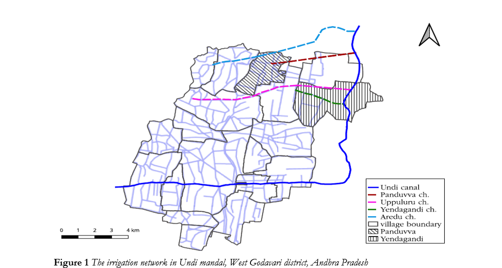
Source: Map generated by authors using Web Map Services (WMS) of the Andhra Pradesh Space Applications Centre, Government of Andhra Pradesh.
The barrage diverts water through three head sluices that form separate irrigation systems in the delta region under the Godavari Delta System – Eastern, Central Delta irrigation systems in East Godavari district and Western Delta irrigation system in West Godavari district. The Western Delta irrigation system has an ayacut of 5.3 lakh acres, irrigated by 11 canals with a total length of 357 kilometres.
Undi mandal is irrigated by the Undi canal, part of the Western Delta irrigation system. Water flows into the Godavari West (GW) Main canal from the Vijjeswaram head sluice, which has a discharge capacity of 9,937 cusecs. It branches into three – the Kakarparru canal, the Eluru canal, and the Venkayya and Weyyeru canal. The Undi canal branches off from the Venkayya and Weyyeru canal at the Chilkampadu lock. It is 32 km long, and has an ayacut of 81,488 acres. The discharge requirement at the head of the Undi canal is estimated to be 1,235 cusecs, with an irrigation requirement of 70 acres per cusec including drinking water and industrial requirements.
The irrigation system in the delta consists of a hierarchical network of canals, channels, field channels, and drains. In general, the irrigation canals and drains are two separate systems. Irrigation canals branch into channels, which may further branch into field channels at the lowest level in the hierarchy. The drainage network consists of minor, medium, and major drains, which ultimately discharge into the sea. Water can enter a field directly from a channel, through a field channel, or as run-off from another field. Some field channels serve both irrigation and drainage functions, when water drains from an upstream field to irrigate a downstream field. In such cases, where the field channel serves both functions, there are concerns regarding the quality of water available to the fields downstream.
The Water Resources Department is responsible for the regulation of water flow, and the upkeep and maintenance of the canals, channels, and drains, but not the field channels. The management and distribution of canal water and field channels are under the purview of Water Users’ Associations, local collectives of landholders, established under the Andhra Pradesh Farmers’ Management of Irrigation Systems Act, 1997.
Water is released from the barrage on June 1 each year. In the first 15 days, the water is used for cleansing the canals and filling the many water tanks in the region. The exercise is repeated between November 15 and December 1, prior to the dalwa crop. The system is shut down for around 45 days between April 15 and May 31 for maintenance.
Regulation is heavier during the sarwa season, when the south-west monsoon brings rain between June and September and the water level requires careful management. The water is regulated through locks and sluices across the channels, operated by lascars – ground-level officers of the Water Resources Department. The department taxes each landowner at Rs 200 per acre for the first crop and Rs 150 per acre for the second.
Concerns Regarding Water Quality
The irrigation system has been central to the agricultural prosperity of the Godavari delta for more than a century and a half. Yet the abundance of water supply has not translated into a reliable supply of drinking water. Many households depend on water purchased from the market or supplied through Corporate Social Responsibility (CSR) efforts of private capital. Concerns over declining water quality are widespread, particularly about salinity associated with the expansion of aquaculture. Field channels that serve functions of both irrigation and drainage are potential points of conflict, in particular when a shrimp/fish tank and a rice field are linked to the same field channel. In such areas where a field channel serves both functions, better planning involving the Water Users’ Associations, panchayat, and the Water Resources Department can ensure that the two systems do not mix. Within this system, the Water Resources Department’s role remains primarily focused on regulating and maintaining the water supply infrastructure.